

After a winter and spring of planning, training and fundraising, the Cycle of Hope Ride the Canadian Rockies hit the highway. Sporting our distinctive jerseys, we were an impressive group as we left Jasper along the Icefields Parkway on route to Banff.
Day One – 105 km
The first day we make it as far as the Columbia Icefields at 105 kilometers. The overall route for the day was a steady, slow incline, about 1000 meters over the entire day. There was one brutally difficult incline at about 90 kilometers, which with the heat the day was more than some of us could manage. (It was 27 degrees with an in-your-face wind.) I bailed out at the 80-kilometer lunch spot, as did many. It was the first day, after all, with many more days and kilometers to come. I remembered the sage advice of one of the experienced riders that “This is a ride, not a race.” Better to pack it earlier and avoid injury or illness.
 Though a tough day of riding, there were many highlights to make the day worthwhile. The majority of route followed near the shores of the Athabasca River, still flowing fast with ice melt from the mountains. A well-marked short detour off the main route, heads to Athabasca Falls. Though not a large water fall, the swirls and twists of the waterfall are dramatic. A recommended stop.
Beautiful outlooks crop up along the highway, usually at the top of a long climb, which made for great breaks and impressive views.
The Columbia Icefields at the end of our day, is a living example of the receding of the mountain glaciers. (Dare I say global warming?) They are the largest icefields in the Rockies and because they are located adjacent to a highway, they are the most visited. There is an extremely busy information center at the site and it is possible to take tours up to the Athabasca Glacier.


The key piece of information that I took away from being here is the dramatic reduction of the size of the Athabasca Glacier since 1844. The first photo above shows the size of the ice sheet in 1844 which at the time would have continued across the current highway and covered the entire parking lot at the information center. The second photo which I took from the balcony on the information center shows where it now ends. You can see how far it has receded from the highway. The information panel tactfully states ”Through the centuries, changes in world climate have caused glaciers to expand and shrink as the balance between snowfall and ice melt shifts.” Hum. Something to think about.
Day Two – 102 km
 The unrelenting climb at the end of day one was flipped on its head, as we started day two with an exhilarating downhill, that ran for close to 11 kilometers. Have a peak at the valley below in the accompanying photo to get a sense of the dramatic drop at the start of the day. Much chatter during dinner that evening centered on how fast everyone went down this stretch. I managed 50 kilometers per hour. Some others managed in excess of 70. Many of the men seemed quite concerned that their wives would find out how fast they were going!
 The easier riding tempo of the morning provided a bit more opportunity to enjoy the surroundings. Midway through the morning, my eyes were distracted by a bright yellow patch in the ditch. My initial thought was that it was some discarded clothing. My mind, doing double time, sorted out that they were yellow lady slippers, a plant that I spot periodically on some of my cycling routes at home. Stopping, turning around and retracing my path, I was lucky enough to see this gem with 14 flowers on one plant. The mind is an interesting thing. Though I would have rode past the lady slipper in a fraction of a second, my mind focused on the thing in the environment that was different. This is considered a beneficial environmental adaptation. The theory goes that the guy who spotted the sabretooth tiger lurking in the grasses first, survived the longest.
The joy of the downhill in the morning was long forgotten as we struggled through the steady climb of the afternoon, under the blazing sun. It’s funny the mental games I played to keep myself amused over a long day. I started counting in French, the cars that drove by, trying to remember which numbers had S’s on the end (quatre-vingts or 80 has an S, but not quatre-vingt-un or 81 or any of the other 80’s. A peculiarity of the French language).
At about 80 kilometers, things really took a turn for the worse as we climbed to the highest point on the Icefields Parkway. I’m not certain how long the climb took but it was 6 kilometers with a 330 meter (1000 foot) gain in elevation. I don’t know how it compared to day one because I didn’t do day 1, of course, but the rise on day 2 was painful. I stopped to walk at least 3 times. I can walk at 5 km/h and I was only riding at 9 km/h at some points and walking seemed much less arduous!
The “light at the end of the tunnel” moment came when I finally saw the end of the passing lane as I climbed the hill. It seemed to me at the time that the once there was no need for a passing lane, the steepness of the road must have diminished. Soon enough it did and I reached the high point of our route.
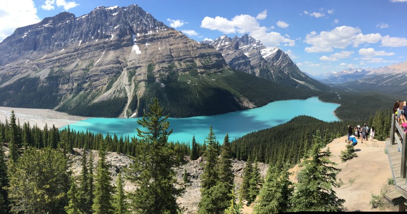 Though not on our “official” route, and as unlikely as it might sound, I took a one kilometer detour further uphill on a side road and then a short hike further up the mountain to see the Bow Summit (2085 meters) which is the highest point on the Icefields Parkway overlooking Peyto Lake. The blue of Peyto Lake and many other lakes in the Rockies is due to the large amounts of glacial “flour” or silt that runs into the lakes in the spring and the summer. The colour first hand is as starling as it appears in pictures.
I had a funny interaction with a gentleman on the Bow Summit. He turned towards me as I was trying to extract myself and my bike from the crowd on the viewing platform. “Oh, it’s you,” he suddenly exclaimed. “My wife and I have been spotting you with the bow in your helmet all along the Icefields Parkway. We saw you in Jasper, at the Icefields Discovery Center and now here!” As a group, we make quite an impression as we ride with our matching jerseys along the parkway. Perhaps, my bows are just a tad bit too conspicuous. We have been a photo-op for tourists and we all have had conversations with tourists about our mission.
The pure pain of the early afternoon was reward with an almost exclusively downhill ride after the Bow Summit, over 13 kilometers, to our destination, Mosquito Creek, with more beautiful views along the way.
Day Three – 93 km
After the crazy ups and downs of day 1 and 2, day 3 was a bit of a gift. Only 93 kilometers, it was mostly downhill, with some moderate uphill sections peppered through the ride, just to keep everyone interested. It included an optional ride up to Lake Louise (4 km uphill). That was not on my agenda, but those who made the ride were really enthusiastic about it. After Lake Louise, we left the Icefields Parkway and cycled the Bow Valley Parkway and Legacy Trail before arriving in Banff. It was one of those days that wasn’t punctuated by any particular highlight (unless one rode the uphill to Lake Louise) but was just an overall pleasant day with beautiful Rocky Mountain views.


What to think?
I don’t think that when I signed up for this ride, I really considered that it would involve such strenuous riding. I know that sounds a little bit unbelievable, perhaps even stupid, but honestly, I don’t think I gave it that much thought. Instead I thought about how “cool” it would be to ride in an iconic Canadian place like the Rockies for Canada’s 150 anniversary and how “cool” it would be to be able to meet Jimmy and Rosalynn Carter at the end. It was only as I started getting closer to spring, did I really start to think about it. Did it motivate me to train more? Well, no to that, too. Endless training across the prairies in Manitoba can only help so much as preparation to conquer the mountains. But, in the end, for me, the last three days have been hard but not horrible. That maybe doesn’t sound like a great endorsement, but there is something special about the Cycle of Hope. As hard as it was, I made it, minus some 25 kilometers on the first day. But nobody cares about that, really. It’s about doing your best, in the company of wonderful people towards a very worthwhile goal of helping finance a Habitat for Humanity home.
One of the riders said something as we rode together at some point in the last three days that I thought was really interesting. You can’t avoid gravity was his basic message. I’d never thought about gravity as a component of cycling but of course, it is. Over the last three days, I’ve found that sometimes gravity is my friend as I careen down 11 kilometer stretches but other times it’s an insurmountable foe. Other times, I beat gravity at its game as I persevere and tackle the climb on my bike, no matter how slowly, and get to enjoy some of the most beautiful parts of Canada.
Other things to know:
If you are keen to see our routes, check out our maps Here.
More than a little apology!
This blog post has been in the works for four days but has been a source of some frustration. I either haven’t had time, or poor internet connections or have just been drop dead tired. So, sorry if this is somewhat old new! Hope you enjoy it, none-the-less.
Still thinking of donating?
Use this link for a donation towards my fundraising efforts: Kim’s Donation Page
Or use this link : Find another cyclist to support

July 12, 2017 at 8:18 am
Proud of you
LikeLike